![](/images/other/stat-length.png)
![Tour Zu Fuß Sankt Englmar - Goldsteig Zuweg Nr.29 Neukirchen - Maibrunn - St. Englmar - Photo](https://media.geolcdn.com/t/1900/400/c07a4dfb-cae3-45d1-a31d-30fd37f936fd.jpeg&format=pjpeg&maxdim=2)
Goldsteig Zuweg Nr.29 Neukirchen - Maibrunn - St. Englmar
SityTrail - itinéraires balisés pédestres
Tous les sentiers balisés d’Europe GUIDE+
![Länge](/images/other/stat-length.png)
Länge
13 km
![Maximale Höhe](https://static1.geolcdn.com/siteimages/upload/files/1508320355ic_sort_altitude_max_24dp.png)
Maximale Höhe
920 m
![Positive Höhendifferenz](https://static1.geolcdn.com/siteimages/upload/files/1508320355ic_sort_den_pos_24dp.png)
Positive Höhendifferenz
199 m
![Km-Effort](/images/other/stat-length.png)
Km-Effort
17,4 km
![Min. Höhe](https://static1.geolcdn.com/siteimages/upload/files/1508320355ic_sort_altitude_min_24dp.png)
Min. Höhe
365 m
![Negative Höhendifferenz](https://static1.geolcdn.com/siteimages/upload/files/1508320355ic_sort_den_neg_24dp.png)
Negative Höhendifferenz
727 m
![Boucle](https://static1.geolcdn.com/siteimages/upload/files/16400158638029165_repeat_loop_refresh_sync_direction_icon.png)
Boucle
Nein
Kennzeichnung
Erstellungsdatum :
2022-02-11 16:46:53.895
Letzte Änderung :
2022-02-11 16:46:53.895
![Zu Fuß](https://static1.geolcdn.com/sitytour/trail-icons/100.png)
3h57
Schwierigkeit : Einfach
![Scannen Sie diesen QR-Code, um die Tour in der SityTrail-Anwendung zu öffnen](https://capi.geolives.com/qq0zvz2zws4bq2lad0pu/sitytour/trails/3096838/qr.png?size=200)
Kostenlosegpshiking-Anwendung
Über SityTrail
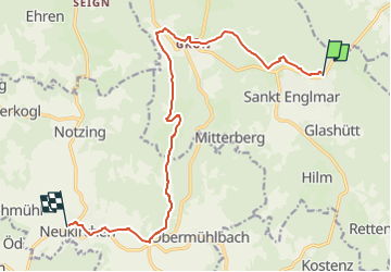
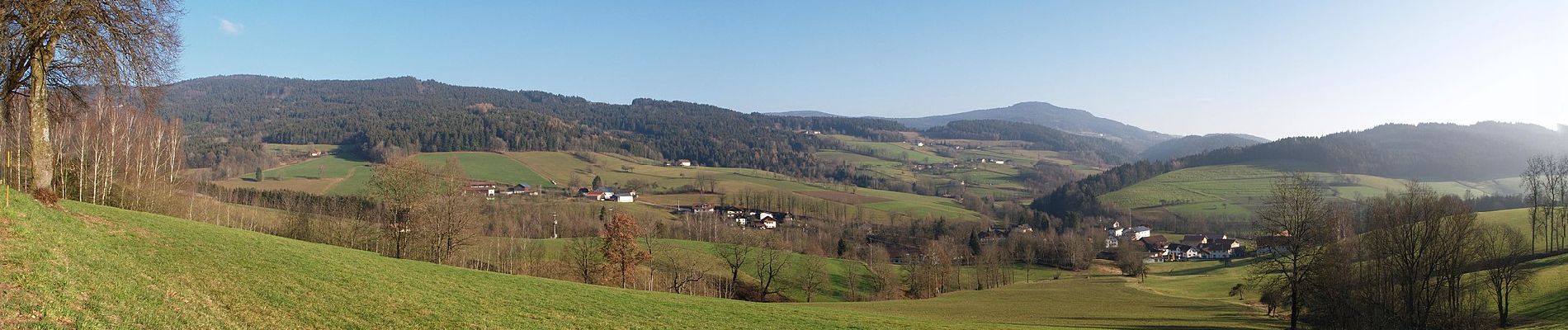
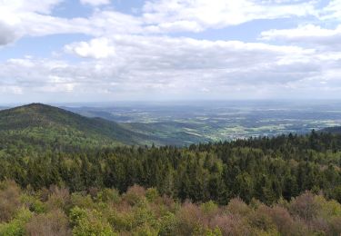
Tour Zu Fuß von 13 km verfügbar auf Bayern, Landkreis Straubing-Bogen, Sankt Englmar. Diese Tour wird von SityTrail - itinéraires balisés pédestres vorgeschlagen.
Beschreibung
Symbol: Blauer, stilisierter s-förmiger Weg und schwarze Schrift "GOLDSTEIG" auf weißem, rechteckigen Grund
Ort
Land:
Germany
Region :
Bayern
Abteilung/Provinz :
Landkreis Straubing-Bogen
Kommune :
Sankt Englmar
Standort:
Unknown
Gehen Sie:(Dec)
Gehen Sie:(UTM)
341559 ; 5430346 (33U) N.
Kommentare
Touren in der Umgebung
![Tour Zu Fuß Achslach - Ferienregion Hirschenstein Rundwanderweg Nr. 4 - Photo](https://media.geolcdn.com/t/375/260/8d1a4ca6-bedb-4629-8e48-f8c38c0536e6.jpeg&format=jpg&maxdim=2)
![Zu Fuß Zu Fuß](https://static1.geolcdn.com/sitytour/trail-icons/100.png)
Ferienregion Hirschenstein Rundwanderweg Nr. 4
Zu Fuß
Einfach
Achslach,
Bayern,
Landkreis Regen,
Germany
![](/images/other/stat-length.png)
11,8 km | 18,8 km-effort
4h 16min
![](https://static1.geolcdn.com/siteimages/upload/files/16400158638029165_repeat_loop_refresh_sync_direction_icon.png)
Ja
![Tour Zu Fuß Sankt Englmar - 5 St. Englmar - Rettenbach - Hilm - St. Englmar - Photo](https://media.geolcdn.com/t/375/260/91b95e96-096c-4639-801a-5d9c80986119.jpeg&format=jpg&maxdim=2)
![Zu Fuß Zu Fuß](https://static1.geolcdn.com/sitytour/trail-icons/100.png)
5 St. Englmar - Rettenbach - Hilm - St. Englmar
Zu Fuß
Einfach
Sankt Englmar,
Bayern,
Landkreis Straubing-Bogen,
Germany
![](/images/other/stat-length.png)
5,2 km | 8,1 km-effort
1h 50min
![](https://static1.geolcdn.com/siteimages/upload/files/16400158638029165_repeat_loop_refresh_sync_direction_icon.png)
Nein
![Tour Zu Fuß Sankt Englmar - Wanderweg 16 - Photo](https://media.geolcdn.com/t/375/260/bb74cc32-554d-4060-813c-69c3c705f8cd.jpeg&format=jpg&maxdim=2)
![Zu Fuß Zu Fuß](https://static1.geolcdn.com/sitytour/trail-icons/100.png)
Wanderweg 16
Zu Fuß
Einfach
Sankt Englmar,
Bayern,
Landkreis Straubing-Bogen,
Germany
![](/images/other/stat-length.png)
5 km | 7,6 km-effort
1h 43min
![](https://static1.geolcdn.com/siteimages/upload/files/16400158638029165_repeat_loop_refresh_sync_direction_icon.png)
Nein
![Tour Zu Fuß Kollnburg - Wanderweg Nr. 20 - Photo](https://media.geolcdn.com/t/375/260/bed0ffb4-0d2d-43fc-b051-4025088bfaea.jpeg&format=jpg&maxdim=2)
![Zu Fuß Zu Fuß](https://static1.geolcdn.com/sitytour/trail-icons/100.png)
Wanderweg Nr. 20
Zu Fuß
Einfach
Kollnburg,
Bayern,
Landkreis Regen,
Germany
![](/images/other/stat-length.png)
7,8 km | 11,5 km-effort
2h 37min
![](https://static1.geolcdn.com/siteimages/upload/files/16400158638029165_repeat_loop_refresh_sync_direction_icon.png)
Ja
![Tour Auto Sankt Englmar - Dagtocht Bayeren - Photo](https://media.geolcdn.com/t/375/260/ext.jpg?maxdim=2&url=https%3A%2F%2Fstatic1.geolcdn.com%2Fsiteimages%2Fupload%2Ffiles%2F15247431544x4.jpg)
![Auto Auto](https://static1.geolcdn.com/sitytour/trail-icons/401.png)
Dagtocht Bayeren
Auto
Sehr leicht
Sankt Englmar,
Bayern,
Landkreis Straubing-Bogen,
Germany
![](/images/other/stat-length.png)
154 km | 205 km-effort
8h 39min
![](https://static1.geolcdn.com/siteimages/upload/files/16400158638029165_repeat_loop_refresh_sync_direction_icon.png)
Ja